Overview:-
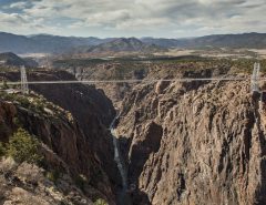
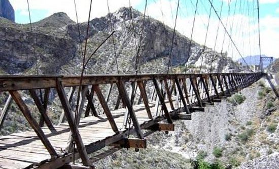
- The Ojuela Bridge or the Mapimi Bridge (Puente de Ojuela, Spanish name) is a suspension bridge located in Mapimí, in the Mexican state of Durango, at the site of the Ojuela Goldmine. The Ojuela Bridge was designed by Wilhelm Hildenbrand and built by the firm of John A. Roebling Sons Company, New York. Completed in 1898 the bridge was restored as a tourist attraction in 1991. It has a main span of 271.5 metres and the distance between the pylons is 315.5 metres. Currently this bridge is only used for pedestrians.
- Approaching the Puente de Ojuela from any direction, Chihuahuan Desert scrub graces the landscape from the highway’s shoulder to the horizon. My day began in Gómez Palacio, with Berenice Martínez-Estrada, at the home of Javier Gustavo Valtierra-Medrano and, from there, we traveled with Gus and his girlfriend, Lupita Nava-Miranda, through Villa Juárez and into the vast desert landscape that surrounds the cities of Torreón, Gómez Palacio, and Lerdo. About an hour later, we passed though the town of Mapimi and embarked on the journey toward the Puente de Ojuela site.
Mines in Colonial Mexico
- About nine kilometers from the town of Mapimi, the site’s main attraction — the suspension bridge — spans more than 300 meters. It was originally constructed in 1898 and, later, redesigned by Santiago Minguín, a German engineer. It was used to move ore from the mine across the canyon to the village of Ojuela, now in ruins. Gold and silver ore were then taken by train,to Mapimi, where it was processed. Mining activity, a guide told us, began as far back as the 16Ith Century, when Spanish prospectors discovered the precious ore. Eventually, Ojuela grew into a village, with its own post office, church, warehouses, stores, and saloons.
- At the beginning of the 19th century, the Peñoles Mining Company took over the mine. Revolutionary activities and flooding later plagued the mine, and mining activities were eventually abandoned, due to recurrent flooding. We were also told that some mining activities, in the chambers nearest the surface, recently resumed, and one sees signs of modern mining on the way into the site.
The Ojuela Ghost Town
- At the entrance to the site, which encompasses not only the bridge site, but also an entire desert mountain landscape, each person pays a small fee to enter. We were cordially received and given a pamphlet on the paid activities available near the bridge. In the building at the entrance, one finds a small souvenir shop.
- Passing through the entranceway, stretches a long, paved, one-lane road up to the Puente de Ojuela. The road is approximately seven kilometers (a little more than four miles) long. It crosses a desert playa and, eventually, climbs up toward the bridge site. There, one enjoys desert scenery along with evidence of past and present mining activities. We observed several visitors hiking over playas as we climbed upward.
- About four kilometers (two and a half miles) from the entranceway, we met up with other visitors waiting to climb the steepest and narrowest part of the highway. There, employees of the bridge site monitor and control visitor traffic flow via radio communication. Although relatively few vehicles travel the route, a steep, climb along a single-lane cobblestone road on the rim of a deep canyon makes traffic control necessary. Although probably intimidating for city folks and tourists unaccustomed to mountain travel, the road is well-built and wide enough for even inexperienced travelers. Although we did observe a few visitors putting their vehicles in four-wheel drive, we and other visitors had no problem climbing up to the parking area in a compact car.
- The ride up the mountain, through ancient slopes, is nearly as exciting as any other part of the trip, as the vehicle passes by fascinating desert plants and rock formations. The whole trip, from the entranceway to the bridge parking lot, takes no longer than 30 minutes. In our case, that included a 5 or 10 minute wait at the radio check point. Of course, suspense builds as one climbs the rocky slope toward the bridge site.