Overview:-
- The Río de la Plata — rendered River Plate in British English and the Commonwealth and La Plata River (occasionally Plata River) in other English-speaking countries — is the river and estuary formed by the confluence of the Uruguay and the Paraná rivers. It empties into the Atlantic Ocean, forming a funnel-shaped indentation on the southeastern coastline of South America.
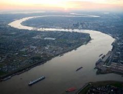
- The river is about 290 kilometres (180 mi) long, and it widens from about 2 kilometres (1.2 mi) at its source to about 220 kilometres (140 mi) at its mouth. It forms part of the border between Argentina and Uruguay, with the major ports and capital cities of Buenos Aires and Montevideo on its western and northern shores, respectively. The coasts of La Plata are the most densely populated areas of Argentina and Uruguay.
Geography
- The Río de la Plata begins at the confluence of the Uruguay and Paraná rivers at Punta Gorda and flows eastward into the South Atlantic Ocean. No clear physical boundary marks the river’s eastern end; the International Hydrographic Organization defines the eastern boundary of the Río de la Plata as a line joining Punta del Este, Uruguay and Cabo San Antonio, Argentina.
- Though it is generally spoken of as a river, the Río de la Plata is considered by some geographers to be a gulf or marginal sea of the Atlantic Ocean. For those who regard it as a river it is the widest in the world, with a maximum width of about 220 kilometres (140 mi) and a total surface area of about 35,000 square kilometres (14,000 sq mi).
Islands and shoals
- The upper river contains several islands, including Oyarvide Island and the Solís Islands in Argentine waters and Juncal Island, Islote el Matón, Martín García Island and Timoteo Domínguez Island in Uruguayan waters. Because of deposition of sediments from the heavy stream load carried down from the river’s tributaries, the islands in the Río de la Plata generally grow over time.
- A submerged shoal, the Barra del Indio, divides the Río de la Plata into an inner freshwater riverine portion and an outer brackish estuarine portion. The shoal is located approximately between Montevideo and Punta Piedras (the northwest end of Samborombón Bay).
- The inner fluvial zone is about 180 kilometres (110 mi) long and up to 80 kilometres (50 mi) wide, with a depth which varies from about 1 to 5 metres (3.3 to 16.4 ft); the depth of the outer estuary zone increases from 5 to 25 metres (16 to 82 ft). The river’s discharge is strong enough to prevent saltwater from penetrating to the inner portion.
Hydrology
- The Río de la Plata behaves as an estuary in which freshwater and seawater mix. The freshwater comes principally from the Paraná River (one of the world’s longest rivers and La Plata’s main tributary) as well as from the Uruguay River and other smaller streams. Currents in the Río de la Plata are dominated by tides reaching to its sources and beyond, into the Uruguay and Paraná rivers. Both rivers are tidally influenced for about 190 kilometres (120 mi). The tidal ranges in the Río de la Plata are small, but its great width allows for a tidal prism important enough to dominate the flow regime despite the huge discharge received from the tributary rivers.
- The river is a salt wedge estuary in which saltwater, being more dense than freshwater, penetrates into the estuary in a layer below the freshwater, which floats on the surface. Salinity fronts, or haloclines, form at the bottom and on the surface, where fresh and brackish waters meet. The salinity fronts are also pycnoclines due to the water density discontinuities. They play an important role in the reproductive processes of fish species.
Drainage basin
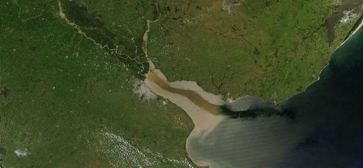
- Satellite image of the Paraná and Uruguay rivers emptying into the Río de la Plata. Due to the relatively calm surface of the estuary and the angle of the Sun relative to the satellite, the current of the river flowing out into the Atlantic is visible.
- The Río de la Plata’s drainage basin (sometimes called the Platine basin or Platine region) is the 3,170,000-square-kilometre (1,220,000 sq mi) hydrographical area that drains to the Río de la Plata. It includes areas of southeastern Bolivia, southern and central Brazil, the entire country of Paraguay, most of Uruguay, and northern Argentina. Making up about one fourth of the continent’s surface, it is the second largest drainage basin in South America (after the Amazon basin) and one of the largest in the world.
- Countries Argentina, Uruguay
- Length 290 km (180 mi)
- Width 220 km (137 mi)
- Basin 3,170,000 km2 (1,224,000 sq mi)